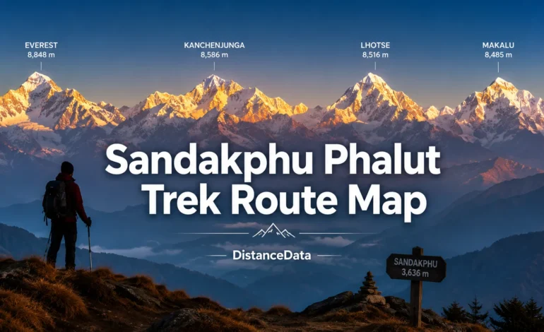
If there is one trek in India where you can see four of the five highest mountains in the world from a single ridge — it is the Sandakphu Phalut trek. Standing at the summit, you see Mount Everest, Kanchenjunga, Lhotse, and Makalu all in one sweeping panorama. No other trek in India offers this. Add to that the famous Sleeping Buddha silhouette formed by the Kanchenjunga massif, rhododendron forests in full bloom, and tea house stays along the Indo-Nepal border — and you have one of the most complete trekking experiences in the entire Himalayas.
At DistanceData, managed by Rohan, here is the complete Sandakphu Phalut trek route map, day-wise itinerary, distances, difficulty, and everything you need before you go.
Sandakphu Phalut Trek: Quick Overview
Before getting into the route details, here is a snapshot of the full trek.
| Detail | Information |
|---|---|
| Trek Location | Singalila National Park, West Bengal |
| Starting Point | Manebhanjan or Dhotrey |
| Ending Point | Rimbik or Srikhola |
| Total Distance | ~80 km (full Sandakphu + Phalut) |
| Duration | 7 to 8 days |
| Highest Point | Sandakphu — 3,636 meters (11,930 ft) |
| Phalut Altitude | 3,600 meters (11,811 ft) |
| Difficulty | Easy to Moderate |
| Best Season | April–May and October–December |
| Nearest Railway | New Jalpaiguri (NJP) |
| Nearest Airport | Bagdogra |
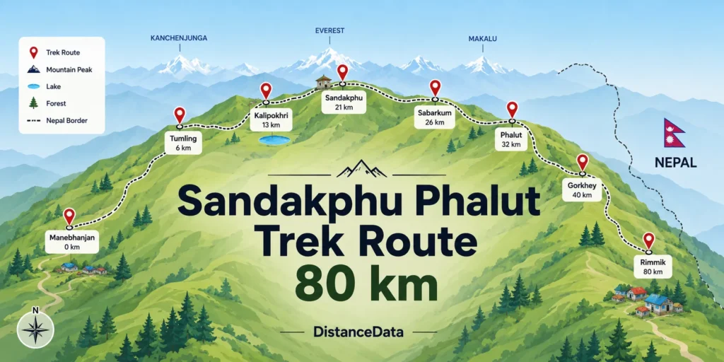
Sandakphu Phalut Trek Route Map: Stage by Stage
The trek begins from Manebhanjan, a quaint town located approximately 90 km from New Jalpaiguri Railway Station and 112 km from Bagdogra Airport. From Manebhanjan, the route follows the Singalila Ridge northward, crossing in and out of Nepal multiple times before reaching Sandakphu and then continuing to Phalut.
Here is the complete route map with distances and altitudes for each stage.
| Stage | Route | Distance | Altitude |
|---|---|---|---|
| Day 1 | NJP/Bagdogra to Manebhanjan/Dhotrey | Drive ~90 km | 1,926 m |
| Day 2 | Dhotrey/Manebhanjan to Tumling | 11 km trek | 2,970 m |
| Day 3 | Tumling to Kalipokhri | 13 km trek | 3,160 m |
| Day 4 | Kalipokhri to Sandakphu via Bikhaybhanjang | 14 km trek | 3,636 m |
| Day 5 | Sandakphu to Sabarkum | 14 km trek | 3,440 m |
| Day 6 | Sabarkum to Phalut, then Gorkhey | 7 km + 15 km | 3,600 m → 2,350 m |
| Day 7 | Gorkhey to Rimbik via Rammam and Srikhola | 28 km trek | 2,290 m |
| Day 8 | Rimbik to NJP/Bagdogra | Drive ~150 km | — |
Day-Wise Sandakphu Phalut Trek Itinerary
Details Itinerary
Day 1 — Travel to Base
The trek starts with a drive from NJP or Bagdogra to Manebhanjan or Dhotrey. A drive of 104 km to Dhotrey takes around 4 hours. The trek can also be started from Manebhanjan, but the route from Dhotrey has fewer crowds, at least for the first day, as both trails eventually converge at Tumling. Arrive by afternoon, rest, and prepare gear for the trek ahead.
Day 2 — Dhotrey to Tumling
This is your first real day on the trail. The path climbs steadily through dense coniferous forest before opening up to the Singalila Ridge. Stone paths are sharp at the beginning, passing by green trees and small abbeys, with the route crossing into the Nepal side of the ridge at Tumling. The first views of Kanchenjunga appear here on clear mornings — a preview of what is ahead.
Day 3 — Tumling to Kalipokhri
Tonglu to Tumling is 2 km and then to Gairibas is 7 km — a gradual descent making an easy route. Gairibas to Kalipokhri is a continuous 6 km climb through the rhododendron forest. There is a small pond at Kalipokhri called the Black Pond which never freezes. The rhododendron forest on this stretch is spectacular in April and May when the flowers are in full bloom.
Day 4 — Kalipokhri to Sandakphu
This is the summit day. From Kalipokhri, the road descends to Bikhaybhanjyang which is a 6 km steep climb to Sandakphu. The final climb is demanding but the reward is extraordinary. Sandakphu is the highest point of the Singalila Ridge and the highest peak in West Bengal. On a clear morning from the summit, you see Everest, Lhotse, Makalu, and Kanchenjunga — four of the five highest peaks in the world — simultaneously. Overnight at Sandakphu.
Day 5 — Sandakphu to Sabarkum
A walk of about 5 hours from Sandakphu brings you to Sabarkum, which is about 14 km from Sandakphu. There is a forest hut at Sabarkum where you can plan to stay for the night. This stretch along the ridge has relatively easier gradient since both Sandakphu and Phalut sit at similar altitudes. The views of the Nepal Himalayas continue throughout the day.
Day 6 — Sabarkum to Phalut, then Gorkhey
Phalut is another 7 km from Sabarkum and takes about 2.5 hours to reach. There is a Trekkers Hut at Phalut. Phalut offers a beautiful panoramic view of Lhotse, Everest, Makalu, and Chomo Lonzo. You can see Everest on one side and the Sleeping Buddha Range on the other side. After Phalut darshan, descend to Gorkhey. The trail from Phalut to Gorkhey is about 15 km and takes 5 hours.
Day 7 — Gorkhey to Rimbik
From Gorkhey, the route passes through Rammam (9 km), Srikhola (12 km), and then finally to Rimbik (7 km) where you can take a shared or private taxi to reach Darjeeling. This descent passes through bamboo forests, chestnut trees, and the beautiful Rammam River which marks the border between Sikkim and West Bengal.
Day 8 — Return to NJP or Bagdogra
Drive from Rimbik back to New Jalpaiguri Railway Station or Bagdogra Airport — approximately 150 km taking around 5 to 6 hours.
Sandakphu Phalut Trek Route Variations
There are several variations to the classic Sandakphu Phalut trek depending on your preferences and time.
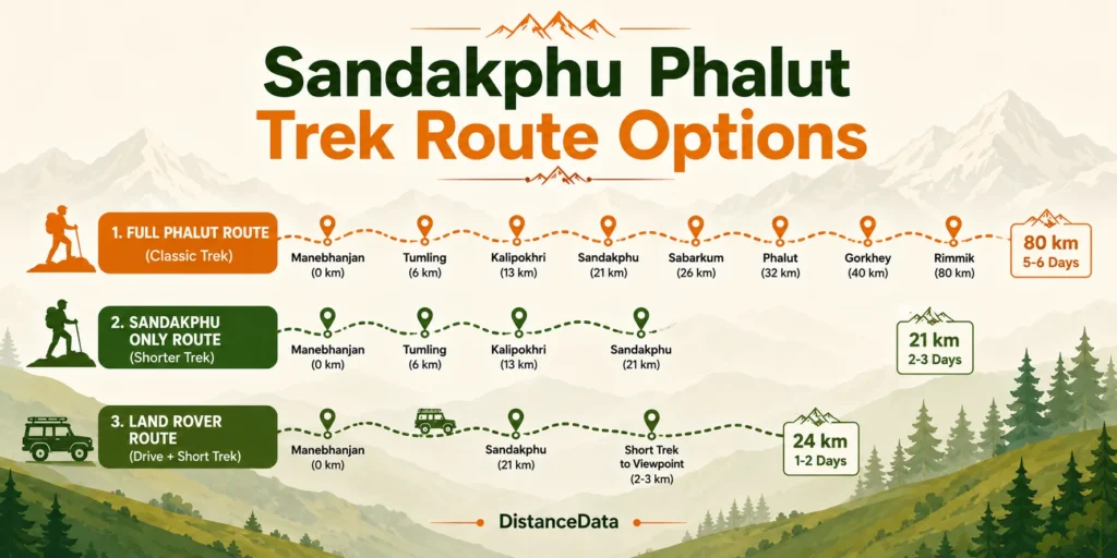
| Route Variation | Duration | Best For |
|---|---|---|
| Full Sandakphu + Phalut (Rimbik end) | 7–8 days | Experienced trekkers, full experience |
| Sandakphu only (Srikhola descent) | 5–6 days | First-time trekkers, shorter time |
| Sandakphu + Phalut via Gorkhey + Srikhola | 7 days | Moderate trekkers |
| Land Rover option to Sandakphu | 3–4 days | Those who cannot do full trek |
The Sandakphu only trek without Phalut covers around 40 km in 4 days which is an easy grade trek that can be completed comfortably by anyone with basic physical fitness. If you are doing this trek for the first time, the Sandakphu-only route is a good starting point.
What Makes the Sandakphu Phalut Trek Unique
This trek stands apart from every other trek in India for several reasons. It is the only trek in India from where you can witness both Mount Everest and Mount Kanchenjunga. The trail runs along the Indo-Nepal border, meaning you are literally walking between two countries for most of the route.
The tea house experience en route the Sandakphu Phalut trek shares a resemblance with treks in Nepal. The villages are unique in their layout, the people have a vibrant culture and warm hospitality. This cultural element sets it apart from Himalayan treks in Uttarakhand or Himachal Pradesh.
The trail attracts bird watchers from all over the world in search of Fire Tailed Sunbird, Golden Bush Robin, Rosy Pipit and many more. For wildlife enthusiasts, the Singalila National Park is also home to the elusive Red Panda.
Permits and Regulations
Every trekker needs a permit to enter Singalila National Park. The permit fee is Rs. 100 for Indians and Rs. 200 for foreigners. It is mandatory to take a guide, and optionally porters, for the trek to Sandakphu and Phalut. Permits are issued at the Forest Department checkpost at Manebhanjan before the trek starts.
For foreigners and OCI cardholders, accommodations are in shared GTA Trekkers Huts at Tonglu, Sandakphu, and Phalut as per current regulations. Indian trekkers have more flexibility with homestay and private lodge options throughout the route.
Trek Cost and Package Pricing
The cost of the trek typically ranges between ₹12,000 to ₹15,000 per person. This usually includes permits, accommodation, meals, and guide fees. Budget trekkers doing it independently can manage for less, but having a guide on this trail is strongly recommended given the route crosses into Nepal multiple times and trail markings can be confusing.
| Package Type | Cost Per Person | Includes |
|---|---|---|
| Budget (Independent) | ₹6,000–₹9,000 | Permits, basic stays |
| Standard Package | ₹12,000–₹15,000 | Permits, stays, meals, guide |
| Premium Package | ₹18,000–₹25,000 | All inclusive, porter, insurance |
Best Time for Sandakphu Phalut Trek
The best seasons for the Sandakphu Phalut trek are pre-monsoon April to June and post-monsoon October to December. During these months the weather is ideal for trekking with clear skies offering unobstructed views of the Himalayan peaks. The rhododendron forests are in full bloom during spring, adding vibrant colors to the landscape, while the autumn months bring crisp air and stunning sunrises.
| Season | Months | Conditions |
|---|---|---|
| Spring | April – May | Rhododendrons blooming, moderate crowds |
| Summer | June | Monsoon begins, not recommended |
| Monsoon | July – September | Avoid — heavy rain, slippery trails |
| Autumn | October – November | Best visibility, crisp air, peak season |
| Winter | December – February | Snow on trail, very cold nights |
October and November give the clearest mountain views. April and May are best if you want to see the rhododendron forests in full colour along the ridge.
Fitness and Preparation
The Sandakphu Phalut trek demands a reasonable level of physical fitness as it includes moderately long daily walks. The trek spans approximately six to eight days and covers a total distance of 63 to 80 kilometres, with an average of around 10 kilometres per day.
You do not need prior mountaineering experience, but daily cardio training for at least 4 to 6 weeks before the trek helps significantly. Hill walking, stair climbing, and jogging are the most useful exercises to prepare for this terrain.