Auli to Kedarnath Distance, Route & Travel Time | DistanceData
Auli and Kedarnath are two of the most visited destinations in Uttarakhand — one famous for its ski slopes and Himalayan views, the other for one of the holiest Shiva temples in India. Many travelers and pilgrims combine both in a single Uttarakhand trip, and it makes perfect sense geographically since both sit in the Garhwal Himalayas.
At DistanceData, managed by Rohan, here is the complete Auli to Kedarnath distance, route breakdown, travel options, and everything you need to plan this journey.
Auli to Kedarnath Distance
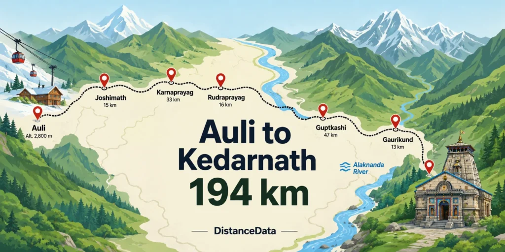
The Auli to Kedarnath distance by road is approximately 194 kilometers. This road distance takes you up to Gaurikund — the last point motorable by vehicle. From Gaurikund, a 16 kilometer trek is mandatory to reach Kedarnath Temple. The aerial straight line distance from Auli to Kedarnath is only 53 kilometers, but the actual road winds through mountain valleys making it nearly four times longer.
The road journey from Auli to Kedarnath takes around 7 to 9 hours, followed by a trek to reach Kedarnath Dham depending on weather and trekking pace.
| Route Segment | Distance |
|---|---|
| Auli to Joshimath | ~15 km |
| Joshimath to Karnaprayag | ~55 km |
| Karnaprayag to Rudraprayag | ~35 km |
| Rudraprayag to Guptkashi | ~45 km |
| Guptkashi to Sonprayag | ~25 km |
| Sonprayag to Gaurikund | ~5 km |
| Gaurikund to Kedarnath Trek | 16 km |
| Total Road + Trek | ~195 km + 16 km |
Best Route: Auli to Kedarnath
The most recommended route is:
Auli → Joshimath → Chamoli → Karnaprayag → Rudraprayag → Guptkashi → Sonprayag → Gaurikund → Kedarnath
From Auli, head towards Rudraprayag, passing through Chamoli and Karnaprayag. From Rudraprayag, continue on NH107 towards Guptkashi, approximately 35 kilometers further. At Guptkashi, take the road toward Sonprayag and then proceed to Gaurikund, the starting point of the trek to Kedarnath.
This route follows the Alaknanda river valley for much of the way before turning into the Mandakini valley at Rudraprayag. The road is well-marked until Sonprayag. After that the mountain terrain gets steeper and narrower as you approach Gaurikund.
One important thing — Auli sits at about 2,500 meters altitude. As you descend toward Karnaprayag and then climb back toward Kedarnath, the altitude changes significantly. Take it slow and let your body adjust, especially if you plan to trek the same day you arrive at Gaurikund.
Travel Options: Auli to Kedarnath
Different – Different Options are avaible
By Road (Cab or Self Drive)
Road is the main and only practical option between Auli and Kedarnath. Auli has no railway station or airport. Most travelers either hire a local cab from Auli or Joshimath, or use their own vehicle.
The road from Auli to Gaurikund is a full mountain drive with narrow stretches after Rudraprayag. Start early — ideally by 5 or 6 AM — so you reach Gaurikund with enough time and energy to begin the trek the same day.
By Helicopter
Helicopter services are available during the pilgrimage season, typically from April to November, depending on weather conditions. The helicopter will land at the designated helipad in Kedarnath, located near the Kedarnath Temple.
Helicopter services operate from Phata, Guptkashi, and Sersi helipads — all reachable from Auli by road. This is ideal for elderly pilgrims or those who want to avoid the 16 km trek. Book tickets well in advance through the official Uttarakhand government portal.
By Ropeway (Within Auli)
The cable car ride plies between Joshimath and Gurson near Auli. One of the highest and longest ropeways in India, it covers approximately 4 kilometers amidst snow-capped mountains. Joshimath to Auli is around 16 km by road or 30 minutes on the ropeway.
The ropeway connects Auli to Joshimath — after which you continue the Kedarnath journey by road. It is a scenic way to descend from Auli before your drive begins.
Travel Options at a Glance
| Mode | Distance | Travel Time | Cost (Approx) | Best For |
|---|---|---|---|---|
| Self Drive / Cab | ~195 km | 7–9 hrs | ₹3,000–₹6,000 | Families, groups |
| Shared Jeep | ~195 km | 9–11 hrs | ₹400–₹800 | Budget travelers |
| Helicopter (last leg) | 16 km aerial | 10–15 mins | ₹3,000–₹5,000 | Elderly, fitness issues |
Auli: More Than Just a Ski Destination
Most people know Auli for its world-class ski slopes, but it is actually an excellent base for the Char Dham Yatra as well. Auli is a scenic gem in Uttarakhand and a great stopover during the Char Dham Yatra. The average maximum temperature in Auli is 20 degrees, making it pleasant and ideal for trekking and sightseeing.
Auli sits at around 2,500 meters altitude and offers some of the finest views of Nanda Devi, Trishul, and Kamet peaks. Once in Auli, you can go trekking to Gurson Bugyal, a stunning green meadow that takes about an hour to trek the 3 km route. Spending a day or two in Auli before heading to Kedarnath is a great way to acclimatize to the altitude and enjoy the mountains before the pilgrimage.
Auli to All Char Dham Distances
Since Auli is centrally located in Garhwal, it is a convenient base for the entire Char Dham circuit. Here are the distances from Auli to all four Dhams.
| Char Dham | Distance from Auli | Travel Time |
|---|---|---|
| Badrinath | ~50 km | 2 hrs |
| Kedarnath | ~194 km | 7–9 hrs + 16 km trek |
| Gangotri | ~310 km | 10–11 hrs |
| Yamunotri | ~397 km | 12–13 hrs |
The Auli to Badrinath distance is approximately 50 km. Travelers can reach Badrinath via Joshimath, which serves as a key transit point. The journey takes around 2 hours by road. This makes Auli the closest major tourist destination to Badrinath in all of Uttarakhand.
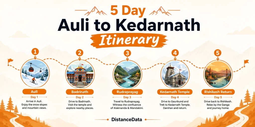
Recommended Itinerary: Auli to Kedarnath
This itinerary works well for travelers already staying in Auli who want to cover Kedarnath as part of their Uttarakhand trip.
| Day | Plan |
|---|---|
| Day 1 | Enjoy Auli — skiing, Gurson Bugyal trek, ropeway ride, acclimatize |
| Day 2 | Depart Auli early, visit Badrinath enroute, drive to Rudraprayag, overnight stay |
| Day 3 | Rudraprayag to Gaurikund via Guptkashi, begin trek, reach Kedarnath, darshan |
| Day 4 | Morning darshan at Kedarnath Temple, trek back to Gaurikund, drive toward Rishikesh |
| Day 5 | Return journey via Rishikesh, Haridwar Ganga Aarti, depart |
If you want to keep it shorter, you can skip Badrinath on Day 2 and drive directly from Auli to Guptkashi in one stretch, staying overnight there before the Gaurikund drive and trek on Day 3.
Key Stops Between Auli and Kedarnath
| Stop | Distance from Auli | What to Know |
|---|---|---|
| Joshimath | ~15 km | Last major town before Auli, good hotels and ATMs |
| Chamoli | ~45 km | Fuel stop, Gopinath Temple nearby |
| Karnaprayag | ~90 km | Alaknanda-Pindar river confluence |
| Rudraprayag | ~125 km | Alaknanda-Mandakini confluence, overnight option |
| Guptkashi | ~165 km | Vishwanath Temple, last major base for Kedarnath |
| Gaurikund | ~190 km | Last motorable point, trek starts here |
Best Time to Travel from Auli to Kedarnath
Both Auli and Kedarnath have seasonal windows that overlap nicely for travelers wanting to visit both.
| Season | Auli | Kedarnath |
|---|---|---|
| January – March | Best for skiing, heavy snow | Temple closed |
| April – June | Pleasant, good for trekking | Temple open, peak pilgrimage |
| July – August | Monsoon, roads risky | Open but difficult |
| September – October | Best weather, clear views | Best time, moderate crowds |
| November – December | Early snowfall, skiing begins | Temple closes |
September and October is the sweet spot for combining Auli and Kedarnath in one trip. Kedarnath weather is at its best, roads are clear after monsoon, and Auli is pleasantly cool with stunning autumn mountain views.
Practical Tips
Withdraw cash at Joshimath before leaving — ATMs are not available beyond Rudraprayag reliably. Carry warm clothes regardless of season as both Auli and Kedarnath are high altitude destinations. Online Char Dham Yatra registration is mandatory before starting the Kedarnath trek — complete this before leaving Auli.
If you are staying in Auli for skiing in winter, note that Kedarnath Temple is closed from November to April. Plan the Kedarnath leg for after April when the temple reopens.