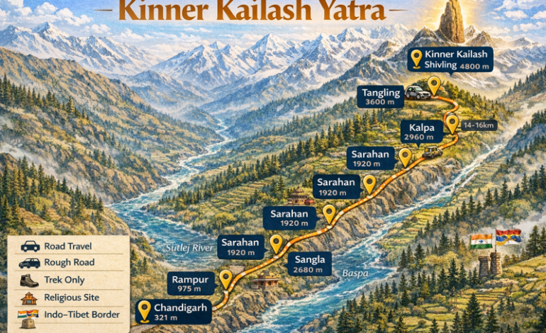
If you are planning the Kinner Kailash Yatra and looking for a detailed Kinner Kailash trek route map, this guide is made exactly for you. Kinner Kailash is one of the most sacred and challenging pilgrimage destinations in India. The main attraction of this yatra is the 79 feet tall natural rock Shivling located at an altitude of approximately 4,800 meters above sea level. Every year thousands of devotees undertake this difficult but deeply rewarding journey during the short summer season.
At DistanceData, Rohan and the team have created this complete guide with the full Kinner Kailash trek route map, day by day itinerary, weather conditions, vehicle details, packing list, permits, budget, and emergency contacts — everything you need in one place before you start your journey.
What is Kinner Kailash and Why is it Special?
Kinner Kailash is a sacred Himalayan peak located in Kinnaur district of Himachal Pradesh standing at approximately 6,050 meters above sea level. The most important religious site here is a 79 feet tall natural rock formation that looks exactly like a Shivling. This Shivling is believed to change color throughout the day — from white in the morning to golden yellow at noon and deep red at sunset. This natural phenomenon makes it one of the most unique and spiritually powerful sites in the entire Himalayan region.
The Kinner Kailash trek route map starts from Chandigarh, passes through Shimla, Kufri, Narkanda, Rampur, Sarahan, Sangla, Batseri, Chitkul, and Kalpa before reaching the Kinner Kailash base at Tangling village. The route passes through the stunning Kinnaur valley which is famous for its apple orchards, ancient temples, Buddhist monasteries, and dramatic landscape where the Sutlej River cuts through deep gorges.
Kinner Kailash Trek Route Map – Full Distance and Altitude Table
Know every stop, distance, and altitude before you start your journey.
| Stop | Distance from Chandigarh | Altitude | Road Type |
|---|---|---|---|
| Chandigarh | 0 km | 321 m | Highway |
| Shimla | 113 km | 2,206 m | Hill Road |
| Kufri | 128 km | 2,560 m | Hill Road |
| Narkanda | 165 km | 2,708 m | Hill Road |
| Rampur | 260 km | 975 m | Mountain Road |
| Sarahan | 315 km | 1,920 m | Mountain Road |
| Sangla | 395 km | 2,680 m | Narrow Road |
| Batseri | 410 km | 2,750 m | Narrow Road |
| Chitkul | 430 km | 3,450 m | Rough Road |
| Kalpa | 450 km | 2,960 m | Mountain Road |
| Tangling Village | 480 km | 3,600 m | Trek Starts Here |
| Kinner Kailash Shivling | Trek Only | 4,800 m | Trek Only |
7 Day Itinerary – Kinner Kailash Trek Route Map
A compact and practical 7 day plan covering the complete Kinner Kailash yatra from Chandigarh and back.
Day 1 – Chandigarh to Rampur via Shimla and Narkanda (260 km)
Start early from Chandigarh and drive straight toward Rampur covering Shimla and Narkanda on the way. This is a long driving day so an early 5 AM start is essential. Stop at Shimla for breakfast and stock up on cash, medicines, and warm clothes as Shimla has the last reliable ATMs and medical stores before the remote Kinnaur region begins. Continue through the beautiful Narkanda apple orchards and then descend sharply down to Rampur in the Sutlej valley. Reach Rampur by evening and rest well.
| Detail | Info |
|---|---|
| Distance | 260 km |
| Travel Mode | Private Taxi or Bus |
| Duration | 8 to 9 hours |
| Trek on This Day | None |
| Difficulty | Easy – long drive |
| Altitude Change | Chandigarh 321 m → Narkanda 2,708 m → Rampur 975 m |
| Breakfast Stop | Shimla – stock up on cash and medicines here |
| Lunch Stop | Narkanda – famous parathas and apple juice |
| Scenery | Shimla hills, apple orchards, Sutlej River gorge |
| Key Task | Withdraw enough cash at Shimla – ATMs rare beyond here |
| Stay | Hotel at Rampur – Rs. 600 to Rs. 2,000 |
Day 2 – Rampur to Sangla via Sarahan (135 km)
Start from Rampur and drive to Sarahan first where the famous Bhimakali Temple is located. Spend 1 to 2 hours at the temple which is one of the most important temples in Himachal Pradesh with stunning Himachali and Buddhist architecture. Then continue driving into the Sangla Valley. As you enter the Sangla Valley the scenery becomes dramatically beautiful with massive snow peaks surrounding you and the crystal clear Baspa River running alongside the road. Reach Sangla by afternoon and spend the rest of the day resting and acclimatizing.
| Detail | Info |
|---|---|
| Distance | 135 km |
| Travel Mode | Private Taxi |
| Duration | 5 to 6 hours |
| Trek on This Day | None |
| Difficulty | Easy to Moderate |
| Altitude Change | Rampur 975 m → Sarahan 1,920 m → Sangla 2,680 m |
| Must Visit | Bhimakali Temple at Sarahan – carry shawl for entry |
| Scenery | Sangla Valley, Baspa River, massive snow peaks |
| Key Task | Acclimatize at Sangla – rest the entire afternoon |
| Stay | Hotel at Sangla – Rs. 800 to Rs. 2,500 |
Day 3 – Sangla to Chitkul and Kalpa (85 km)
This is one of the most scenic days on the entire Kinner Kailash trek route map. Start early and drive to Chitkul which is the last inhabited village on the Indo-Tibetan border and the highest village accessible by road in the Baspa Valley at 3,450 meters. Spend 2 hours exploring Chitkul, visit the ancient temple, and walk to the riverside for stunning views. Then drive back from Chitkul and continue to Kalpa. Kalpa offers the most spectacular direct view of the Kinner Kailash range. Watch the sunset on Kinner Kailash from Kalpa — it is one of the most breathtaking sights in the entire Himalayas.
| Detail | Info |
|---|---|
| Distance | 85 km total |
| Travel Mode | Private Taxi |
| Duration | 6 to 7 hours with stops |
| Trek on This Day | Short 1 to 2 km walk at Chitkul |
| Difficulty | Easy |
| Altitude | Sangla 2,680 m → Chitkul 3,450 m → Kalpa 2,960 m |
| Must Visit | Chitkul village and ancient temple |
| Scenery | Last Indo-Tibet border village, glaciers, Kinner Kailash view from Kalpa |
| Must Do | Watch sunset on Kinner Kailash from Kalpa viewpoint |
| Key Task | Rest well at Kalpa – trek preparation begins |
| Stay | Hotel at Kalpa – Rs. 800 to Rs. 2,500 |
Day 4 – Kalpa to Tangling Base Camp (30 km drive)
Drive from Kalpa down to Powari and then up to Tangling village which is the official starting point of the Kinner Kailash parikrama trek. Tangling sits at approximately 3,600 meters and serves as the base camp for the trek. This is a short drive day which is intentionally kept easy so you can save your energy for the big trek tomorrow. Register your name at the forest department check post at Tangling. Spend the afternoon preparing your backpack, eating a hearty meal, and sleeping early. A 3 AM wake up call awaits you tomorrow.
| Detail | Info |
|---|---|
| Drive Distance | 30 km |
| Travel Mode | Taxi to Powari then Local Vehicle |
| Duration | 1.5 to 2 hours |
| Trek on This Day | Short 2 km acclimatization walk |
| Difficulty | Easy |
| Altitude Change | Kalpa 2,960 m → Tangling 3,600 m |
| Key Task | Register at forest check post – mandatory |
| Important | Sleep by 8 PM – very early start tomorrow |
| Scenery | Valley views, Sutlej River below, Kinner Kailash straight ahead |
| Stay | Dharamshalas or camps at Tangling – Rs. 200 to Rs. 500 |
Day 5 – Tangling to Kinner Kailash Shivling Darshan and Back (Trek Day)
This is the most important, most difficult, and most rewarding day of the entire Kinner Kailash trek route map journey. Wake up at 3 AM, have a light breakfast, and start trekking by 4 AM. The trek from Tangling to the sacred Shivling at 4,800 meters is approximately 14 to 16 km one way through very steep and rocky Himalayan terrain. There are no tea stalls or shops anywhere on this trek so carry all your food, water, and medicines from Tangling. The moment you see the massive 79 feet natural Shivling standing against the brilliant blue Himalayan sky is something you will never forget for the rest of your life. After darshan and puja return to Tangling the same day.
| Detail | Info |
|---|---|
| Trek Distance | 14 to 16 km one way |
| Total Trek Distance | 28 to 32 km round trip |
| Wake Up Time | 3:00 AM |
| Departure Time | 4:00 AM |
| Trek Duration | 6 to 8 hours uphill |
| Return Duration | 4 to 5 hours downhill |
| Trek Difficulty | Very Hard – steep rocky terrain at very high altitude |
| Altitude Change | Tangling 3,600 m → Shivling 4,800 m |
| Trail Condition | Rocky, steep, narrow, snow patches possible |
| No Facilities on Trek | Carry all food, water, and medicines |
| Scenery | Dramatic ridges, glaciers, and the sacred 79 feet Shivling |
| Key Task | Darshan and puja at natural Shivling |
| Stay | Tangling camp after return |
Day 6 – Tangling to Shimla via Kalpa and Rampur (280 km)
After the exhausting trek day, start the return journey toward Shimla. This is a long driving day but your body will feel relieved at the dropping altitude. Drive from Tangling back to Kalpa for a final breakfast and one last look at the magnificent Kinner Kailash range. Then continue through Rampur and Narkanda back up to Shimla. Reach Shimla by evening and celebrate the successful completion of your sacred yatra with a nice dinner and a well deserved rest.
| Detail | Info |
|---|---|
| Distance | 280 km |
| Travel Mode | Private Taxi |
| Duration | 8 to 9 hours |
| Trek on This Day | None |
| Difficulty | Easy – long but comfortable drive |
| Altitude Change | Tangling 3,600 m → Shimla 2,206 m |
| Breakfast Stop | Kalpa – final view of Kinner Kailash |
| Lunch Stop | Rampur |
| Scenery | Kinnaur valley, Sutlej River, Narkanda apple orchards |
| Key Task | Celebrate yatra completion at Shimla Mall Road |
| Stay | Hotel at Shimla – Rs. 800 to Rs. 3,000 |
Day 7 – Shimla to Chandigarh and Onward Journey (113 km)
The final day of the Kinner Kailash trek route map journey brings you back to Chandigarh from where you can take a train, bus, or flight back to your home city. The drive from Shimla to Chandigarh takes about 4 to 5 hours on the National Highway. Reach Chandigarh by afternoon and proceed for your onward journey home carrying memories and blessings that will last a lifetime.
| Detail | Info |
|---|---|
| Distance | 113 km |
| Travel Mode | Bus or Private Taxi |
| Duration | 4 to 5 hours |
| Trek on This Day | None |
| Difficulty | Very Easy |
| Altitude Change | Shimla 2,206 m → Chandigarh 321 m |
| Key Task | Book return train or flight well in advance |
| Stay | Departure from Chandigarh |
Vehicle Guide for Kinner Kailash Trek Route
Know exactly which vehicle to use for each section of the journey.
| Stretch | Vehicle | Road Condition |
|---|---|---|
| Chandigarh to Shimla | Bus or Taxi | Excellent Highway |
| Shimla to Narkanda | Taxi or Bus | Good Hill Road |
| Narkanda to Rampur | Taxi | Winding Mountain Road |
| Rampur to Sarahan | Taxi | Narrow Mountain Road |
| Sarahan to Sangla | Taxi | Narrow Valley Road |
| Sangla to Chitkul | Taxi | Rough Road |
| Chitkul to Kalpa | Taxi | Mountain Road |
| Kalpa to Tangling | Taxi then Local Vehicle | Very Rough Road |
| Tangling to Shivling | Trek Only | No Road – 14 to 16 km Trek |
Weather and Best Time to Visit
Plan your trip in the right season to avoid route closures and dangerous conditions.
| Month | Temp at Kalpa | Condition | Should You Go? |
|---|---|---|---|
| Jan – Mar | -10°C to 0°C | Route Closed | No |
| April | -2°C to 10°C | Unstable | Not Recommended |
| May | 5°C to 18°C | Route Opens | Good |
| June | 8°C to 20°C | Best Weather | Best Time |
| July | 7°C to 18°C | Some Rain | Possible |
| August | 7°C to 17°C | Landslide Risk | Avoid |
| September | 5°C to 15°C | Clear Skies | Very Good |
| October | 0°C to 10°C | Cold but Clear | Good |
| November+ | Below 0°C | Route Closes | No |
Permits Required
All permits must be arranged before crossing into the Kinnaur restricted zone.
| Permit | Where to Get | Documents Needed |
|---|---|---|
| Inner Line Permit | DC Office Recong Peo or Online | Aadhaar Card, Passport Photos |
| Forest Department Permit | Tangling Check Post | ID Proof |
| Foreign National Permit | District Office | Passport and Visa Copy |
Packing List
Packing right can make the difference between a safe trek and a dangerous one.
| Item | Importance |
|---|---|
| Heavy Woolen Jacket and Thermals | Must Have |
| Waterproof Trekking Shoes | Must Have |
| Rain Poncho | Must Have |
| Sleeping Bag -10°C Rated | Must Have |
| Trekking Poles | Must Have |
| Sunscreen SPF 50 and Sunglasses | Must Have |
| Headlamp and Power Bank | Must Have |
| First Aid Kit and Medicines | Must Have |
| Water Bottle and Purification Tablets | Must Have |
| Sufficient Cash | Must Have |
| Aadhaar Card and Passport Photos | Must Have |
| Warm Gloves and Woolen Cap | Must Have |
| Dry Snacks and Energy Bars | Recommended |
| Gaiters for Snow Sections | Recommended |
Total Budget Table
Plan your complete expenses for the Kinner Kailash yatra.
| Expense | Cost Per Person |
|---|---|
| Chandigarh to Shimla Bus | Rs. 200 to Rs. 500 |
| Shimla to Kalpa Taxi | Rs. 3,000 to Rs. 6,000 |
| Kalpa to Tangling Local Vehicle | Rs. 500 to Rs. 1,000 |
| Accommodation 7 Days | Rs. 4,000 to Rs. 12,000 |
| Food Entire Trip | Rs. 2,000 to Rs. 4,000 |
| Inner Line Permit | Rs. 200 to Rs. 500 |
| Porter or Guide Optional | Rs. 600 to Rs. 800 per day |
| Miscellaneous | Rs. 1,000 to Rs. 2,000 |
| Total Budget | Rs. 12,000 to Rs. 27,000 |
Accommodation on the Route
Comfortable and affordable stays available at every major stop.
| Location | Options | Cost Per Night |
|---|---|---|
| Shimla or Kufri | Hotels | Rs. 800 to Rs. 3,000 |
| Rampur | Hotels | Rs. 600 to Rs. 2,000 |
| Sarahan | Hotels and HPTDC | Rs. 700 to Rs. 2,500 |
| Sangla | Hotels and Homestays | Rs. 800 to Rs. 2,500 |
| Kalpa | Hotels and Guesthouses | Rs. 800 to Rs. 2,500 |
| Tangling | Dharamshalas and Camps | Rs. 200 to Rs. 500 |
Altitude Sickness Tips
Kinner Kailash reaches 4,800 meters so altitude sickness is a real and serious risk.
The trek to Kinner Kailash Shivling goes up to 4,800 meters which is a very high altitude. Never rush the acclimatization process and always spend extra time at Sangla and Kalpa before going to Tangling. Drink at least 3 to 4 liters of water every day and avoid alcohol completely during the yatra. Walk slowly at all times even if you feel perfectly fine. If you experience severe headache, vomiting, confusion, or difficulty breathing descend to a lower altitude immediately without waiting. People with heart conditions, high blood pressure, or breathing problems must consult a doctor before attempting this trek.
Nearby Places to Visit
Do not miss these beautiful places near the Kinner Kailash route.
| Place | Distance | Highlight |
|---|---|---|
| Bhimakali Temple Sarahan | At Sarahan | Ancient stunning temple |
| Chitkul Village | 35 km from Sangla | Last village on Indo-Tibet border |
| Baspa River | Along Sangla Valley | Crystal clear Himalayan river |
| Hu-Bu-Lan-Kar Monastery | At Kalpa | Ancient Buddhist monastery |
| Recong Peo | 14 km from Kalpa | District headquarters |
| Suicide Point Kalpa | At Kalpa | Dramatic viewpoint over deep gorge |
Emergency Contact Numbers
Save these numbers before you leave for the Kinner Kailash yatra.
| Service | Number |
|---|---|
| Himachal Tourism Helpline | 0177 – 2625924, 2625511 |
| National Emergency | 112 |
| Ambulance | 108 |
Final Thoughts
The Kinner Kailash trek route map is a journey that combines breathtaking natural beauty with deep spiritual significance. From the magnificent Sangla Valley to the ancient temples of Sarahan, the last village of Chitkul, the stunning views from Kalpa, and finally the awe inspiring sight of the 79 feet natural Shivling standing at 4,800 meters — every single day of this yatra is unforgettable.
At DistanceData, Rohan and the team are committed to giving every traveler the most accurate, helpful, and trustworthy travel information so that your sacred journey is safe, well planned, and truly memorable. Plan well, walk slowly, respect the mountains and local culture, and carry the blessings of Kinner Kailash home with you.
All information is researched and verified. Always confirm latest permit and route conditions with local Himachal Pradesh authorities before starting your yatra.