
Sar Pass Trek Route Map, Distance & Itinerary | DistanceData
If you are looking for a trek that has everything — dense pine forests, high altitude meadows, snow covered passes, traditional Himachali villages, and a thrilling snow slide descent — the Sar Pass trek is the one. Located in the Parvati Valley of Himachal Pradesh, this is one of the most popular moderate treks in India and a perfect first Himalayan adventure for beginners who are reasonably fit.
At DistanceData, managed by Rohan, here is the complete Sar Pass trek route map, day-wise itinerary, campsite details, difficulty level, and everything you need before you lace up your boots.
Sar Pass Trek: Quick Overview
The total trekking distance of the Sar Pass Trek is around 48 kilometers, spread across 5 to 6 days. Each day typically involves 5 to 7 hours of walking depending on terrain, weather conditions, and individual pace.
| Detail | Information |
|---|---|
| Location | Parvati Valley, Kullu District, Himachal Pradesh |
| Starting Point | Kasol |
| Ending Point | Barshaini |
| Total Distance | ~48 km |
| Duration | 5 to 6 Days |
| Highest Point | Sar Pass — 4,200 m (13,800 ft) |
| Difficulty | Easy to Moderate |
| Best Season | May–June and September–October |
| Nearest Town | Kasol |
| Nearest Airport | Bhuntar (Kullu-Manali Airport) — 31 km |
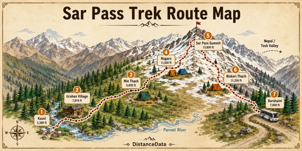
Sar Pass Trek Route Map: Stage by Stage
The journey starts in Kasol and passes through Grahan, Min Thach, Nagaru, Sar Pass, and Biskeri Thach. The trail covers a distance of approximately 48 km. This crossover route connects Parvati Valley to Tosh Valley, making it one of the most rewarding crossover treks in Himachal Pradesh.
| Stage | Route | Distance | Altitude |
|---|---|---|---|
| Day 1 | Kasol to Grahan Village | 9 km | 2,380 m |
| Day 2 | Grahan to Min Thach | 9 km | 2,950 m |
| Day 3 | Min Thach to Nagaru | 10 km | 3,560 m |
| Day 4 | Nagaru to Sar Pass to Biskeri Thach | 12 km | 4,200 m → 3,380 m |
| Day 5 | Biskeri Thach to Pulga to Barshaini | 8 km + drive | 2,400 m |
Day-Wise Sar Pass Trek Itinerary
Day 1 — Kasol to Grahan Village
The trek commences from Kasol, leading through dense pine forests alongside the Grahan Nallah. The trail is well-defined and frequented by locals. Grahan is a serene village offering a glimpse into the traditional Himachali lifestyle.
This first day is a gentle introduction to the trail. The path runs alongside a clear mountain stream through tall deodar and pine trees. Grahan village feels like the Himalayas before tourism changed things — stone houses, wooden architecture, and locals going about their day. Spend the night here and rest well because the next few days get progressively more demanding.
Day 2 — Grahan to Min Thach
The trail ascends steeply through the forest, leading to Min Thach, a beautiful meadow surrounded by towering peaks. The area is used by locals for cattle grazing and offers panoramic views of the valley.
Min Thach is one of the most peaceful camps on the Sar Pass Trek route. This is where the route starts feeling serious. The forest gradually thins as you gain altitude and the meadow opens up with mountain views on all sides. Camp here and wake up to one of the finest Himalayan mornings on the entire trek.
Day 3 — Min Thach to Nagaru
The ascent becomes steeper and snow patches often appear as you approach Nagaru. This is the acclimatization day — your body is adjusting to the altitude and the terrain is pushing back a little more. Take it slow, drink plenty of water, and do not rush. Snow begins appearing on the trail from this point depending on the season, adding a completely different character to the landscape.
Day 4 — Nagaru to Sar Pass to Biskeri Thach
This is the summit day — and the highlight of the entire trek. An early morning ascent leads to Sar Pass, where trekkers are greeted with a panoramic view of snow-covered peaks. The descent to Biskeri Thach includes a thrilling snow slide, adding an element of adventure.
The altitude at Sar Pass is 13,600 ft and the distance covered on this day is 12 km with 7 to 8 hours of trekking. Start by 5 AM. The snow climb to the pass is steep and demands every bit of energy you have built up over the previous days. The moment you reach the top, the panoramic view of the Parvati and Tosh valleys stretching out below is something you will not forget easily. The snow slide descent is a pure moment of joy after the hard climb.
Day 5 — Biskeri Thach to Pulga to Barshaini
The trail descends through dense forests and picturesque meadows, leading to Pulga Village, known for its charming wooden houses and vibrant culture. A short trek to Barshaini is followed by a drive back to Kasol, marking the end of a memorable journey.
This final day is a long descent through forest and meadow, ending at Barshaini from where a short drive takes you back to Kasol. Most groups reach Kasol by early afternoon — enough time for a proper meal and to celebrate completing the trek.
Sar Pass Trek Route Highlights
What makes the Sar Pass trek route special is the variety packed into five days. Very few treks in India give you this much landscape diversity in such a compact itinerary.
| Highlight | Location on Route |
|---|---|
| Parvati River crossing | Kasol start |
| Traditional Himachali village | Grahan Village — Day 1 |
| Alpine meadow camping | Min Thach — Day 2 |
| First snow patches | Nagaru — Day 3 |
| Sar Pass summit views | Day 4 — 13,800 ft |
| Thrilling snow slide descent | Sar Pass to Biskeri — Day 4 |
| Tosh Valley views | Biskeri Thach — Day 4 |
| Pulga wooden village | Day 5 descent |
How to Reach Kasol for Sar Pass Trek
The nearest airport to Kasol is Kullu-Manali Airport also known as Bhuntar Airport located approximately 31 km from Kasol. This is the most convenient air route for trekkers coming from distant parts of India. After landing, you can hire a private taxi or board a local bus to reach Kasol.
The closest major railway station is Chandigarh Railway Station, which is well connected to Delhi and other northern cities. From Chandigarh, travelers can continue by bus or taxi to Bhuntar and then onward to Kasol.
From Delhi by road, Kasol is approximately 520 km and takes 12 to 14 hours by bus or car. HRTC buses run from Delhi ISBT Kashmere Gate to Bhuntar, from where local buses or shared taxis go to Kasol. Reaching Kasol a day before the trek starts is strongly recommended.
Sar Pass Trek Difficulty and Fitness Requirements
Sar Pass is often recommended as the best moderate Himalayan trek for beginners, thanks to gradual acclimatization, manageable daily distances, and experienced trek leaders who guide you through all tricky sections.
That said, Day 4 — the summit day — is genuinely demanding. The snow climb to the pass and the long descent make it the most physically draining day. A good level of physical and mental fitness is essential to enjoy the trek safely and comfortably. The trek involves walking 6 to 8 km daily for several days at high altitude. Start preparing at least 4 weeks in advance.
Trek Cost and Packages
| Package Type | Cost Per Person | Includes |
|---|---|---|
| Budget | ₹8,000–₹12,000 | Permits, basic camps, guide |
| Standard | ₹12,000–₹18,000 | Camps, meals, guide, transport |
| Premium | ₹20,000–₹28,000 | All inclusive, porter, insurance |
Best Time for Sar Pass Trek
The best time for Sar Pass trek is May to June and September to October. May to June has daytime temperatures between 12°C to 20°C while nights can drop to 0°C. September to October has cooler days with temperatures between 10°C to 15°C and colder nights sometimes dropping below freezing.
| Season | Months | Conditions |
|---|---|---|
| Pre-monsoon | May – June | Snow on pass, meadows green, ideal for snow slide |
| Monsoon | July – August | Avoid — slippery trails, leeches in forest |
| Post-monsoon | September – October | Clear skies, crisp air, less snow |
| Winter | November – April | Trail closes, heavy snowfall |
May is the most popular month because you get the best snow conditions for the summit day and the snow slide descent. September gives clearer mountain views and fewer crowds.
Nearby Attractions from Kasol
Since you start and end the trek at Kasol, spending an extra day exploring the surrounding area is well worth it.
| Place | Distance from Kasol | Highlight |
|---|---|---|
| Kheerganga | 22 km trek | Natural hot springs, camping |
| Manikaran Sahib | 5 km | Sacred Gurudwara, hot springs |
| Tosh Village | 20 km | Remote Himachali village, views |
| Chalal Village | 1 km | Riverside walk, relaxed vibe |