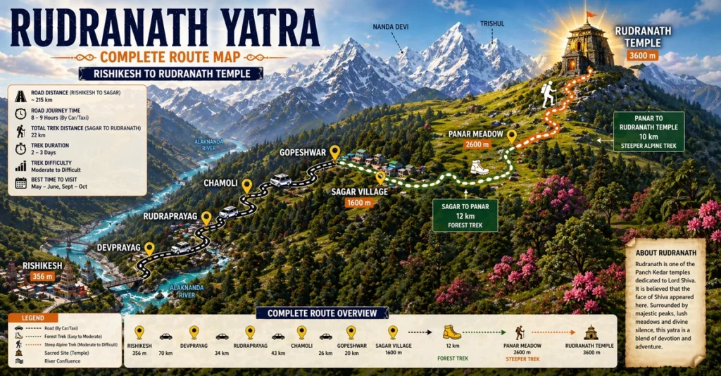
Rudranath Trek Route Map By Expert Trekker
If you are planning the Rudranath Yatra and looking for a detailed Rudranath trek route map, this guide is made exactly for you. Rudranath is one of the five sacred Panch Kedar temples of Uttarakhand and is dedicated to Lord Shiva. It is located at an altitude of approximately 3,600 meters above sea level in the Chamoli district of Uttarakhand. Among all the five Panch Kedar temples, Rudranath is considered the most remote and the most difficult to reach which makes it even more special for devoted pilgrims. The face of Lord Shiva is believed to have appeared at Rudranath which gives this temple its unique religious significance.
At DistanceData, Rohan and the team have created this complete guide with the full Rudranath trek route map, day by day itinerary, weather conditions, vehicle details, packing list, permits, budget, and emergency contacts — everything you need in one place before you start your journey.
What is Rudranath and Why is it Special?
The most remote of all five Panch Kedar temples where the face of Lord Shiva is worshipped.
Rudranath is one of the five Panch Kedar temples of Uttarakhand and is considered the most isolated and spiritually powerful among all five. According to Hindu mythology, after the Kurukshetra war the Pandavas sought blessings from Lord Shiva who disappeared into the ground at five different places. The face of Lord Shiva appeared at Rudranath which is why it is also called the place of the divine face. The temple is surrounded by stunning alpine meadows, dense forests, and breathtaking Himalayan peaks. The journey to Rudranath is long and demanding but every step is filled with natural beauty and spiritual energy.
The Rudranath trek route map starts from Rishikesh, passes through Sagar village which is the base camp, and then follows a beautiful forest and meadow trail through Panar before finally reaching the sacred Rudranath temple at 3,600 meters.
Rudranath Trek Route Map – Full Distance and Altitude Table
Know every stop, distance, and altitude before you start your journey.
| Stop | Distance | Altitude | Mode |
|---|---|---|---|
| Rishikesh | Start | 356 m | Road |
| Sagar Village | 220 km | 1,600 m | Road – Trek Starts |
| Panar | 232 km | 2,600 m | Trek 12 km |
| Rudranath Temple | 242 km | 3,600 m | Trek 10 km |
3 Day Itinerary – Rudranath Trek Route Map
A compact and practical 3 day plan covering the complete Rudranath yatra from Rishikesh and back.
Day 1 – Rishikesh to Sagar Village (220 km Drive)
The journey begins from Rishikesh which is the most convenient starting point for the Rudranath trek route map.
| Detail | Info |
|---|---|
| Distance | 220 km |
| Travel Mode | Car, Taxi, or Bus |
| Duration | 7 to 8 hours |
| Trek on This Day | None |
| Difficulty | Easy – long drive |
| Altitude Change | Rishikesh 356 m → Sagar 1,600 m |
| Lunch Stop | Gopeshwar – last major town before Sagar |
| Scenery | Devprayag, Rudraprayag, Chamoli valley, mountain roads |
| Key Task | Stock up on cash, food, and medicines at Gopeshwar |
| Stay | Guesthouse at Sagar Village – Rs. 300 to Rs. 800 |
Day 2 – Sagar to Rudranath Temple via Panar (22 km Trek)
This is the biggest and most rewarding day of the entire Rudranath trek route map journey. Start very early from Sagar at around 5 AM after a light breakfast. The first 12 km section from Sagar to Panar passes through dense oak and rhododendron forests with beautiful river crossings and gradually opening mountain views.
| Detail | Info |
|---|---|
| Total Trek Distance | 22 km |
| Departure Time | 5:00 AM from Sagar |
| Trek Duration | 9 to 11 hours total |
| Trek Difficulty | Hard – long distance, steep sections, high altitude |
| Altitude Change | Sagar 1,600 m → Panar 2,600 m → Rudranath 3,600 m |
| First Section | Sagar to Panar – 12 km forest trail |
| Rest Stop | Panar meadow – lunch break and rest |
| Second Section | Panar to Rudranath – 10 km steep alpine trail |
| Trail Type | Dense forest then open alpine meadows |
| Highlights | Rhododendron forests, Panar meadow, Himalayan peak views |
| Key Task | Temple darshan and puja at Rudranath |
| Stay | Guesthouse or camp at Rudranath – Rs. 400 to Rs. 800 |
Day 3 – Rudranath Darshan and Return to Sagar and Rishikesh (22 km Trek + Drive)
Wake up very early on Day 3 for the morning aarti and darshan at Rudranath temple. The sunrise view from Rudranath with golden light falling on the surrounding Himalayan peaks is one of the most breathtaking and spiritually moving sights you will ever witness.
| Detail | Info |
|---|---|
| Morning Aarti | 6:00 AM at Rudranath temple |
| Trek Distance | 22 km descent |
| Departure from Rudranath | 8:00 AM |
| Trek Duration | 6 to 7 hours downhill |
| Trek Difficulty | Moderate – descent easier on lungs but hard on knees |
| Altitude Change | Rudranath 3,600 m → Panar 2,600 m → Sagar 1,600 m |
| Rest Stop | Panar meadow – lunch break |
| Drive Distance | 220 km – Sagar to Rishikesh |
| Drive Duration | 7 to 8 hours |
| Key Task | Start early from Rudranath to reach Rishikesh before midnight |
| Stay | Drive back to Rishikesh or overnight at Gopeshwar |
Vehicle Guide for Rudranath Trek Route
Know exactly which vehicle to use for each section of the journey.
| Stretch | Vehicle | Road Condition |
|---|---|---|
| Rishikesh to Devprayag | Bus or Taxi | Good Highway |
| Devprayag to Rudraprayag | Taxi or Bus | Mountain Road |
| Rudraprayag to Gopeshwar | Taxi | Narrow Mountain Road |
| Gopeshwar to Sagar | Taxi or Local Vehicle | Very Narrow Rough Road |
| Sagar to Panar | Trek Only | Forest Trail – No Road |
| Panar to Rudranath | Trek Only | Alpine Trail – No Road |
Weather and Best Time to Visit
Plan your trip in the right season to avoid route closures and dangerous conditions.
| Month | Temp at Rudranath | Condition | Should You Go? |
|---|---|---|---|
| Jan – Apr | -5°C to 5°C | Route Closed, Snow | No |
| May | 8°C to 18°C | Route Opens | Good |
| June | 10°C to 20°C | Best Weather | Best Time |
| July | 8°C to 17°C | Monsoon Rain | Avoid |
| August | 8°C to 16°C | Heavy Rain, Slippery | Avoid |
| September | 6°C to 15°C | Clear Skies | Very Good |
| October | 2°C to 10°C | Cold but Clear | Good |
| November+ | Below 0°C | Route Closes | No |
Permits Required
Registration is mandatory before starting the Rudranath trek.
| Permit | Where to Get | Documents Needed |
|---|---|---|
| Trek Registration | Forest Office at Sagar | Aadhaar Card |
Packing List
Packing right can make the difference between a safe trek and a dangerous one.
| Item | Importance |
|---|---|
| Warm Jacket and Thermals | Must Have |
| Waterproof Trekking Shoes | Must Have |
| Rain Poncho | Must Have |
| Sleeping Bag | Must Have |
| Trekking Poles | Must Have |
| Sunscreen SPF 50 and Sunglasses | Must Have |
| Headlamp and Power Bank | Must Have |
| First Aid Kit and Medicines | Must Have |
| Water Bottle | Must Have |
| Sufficient Cash | Must Have |
| Aadhaar Card | Must Have |
| Dry Snacks and Energy Bars | Must Have |
| Warm Gloves and Woolen Cap | Must Have |
Total Budget Table
Plan your complete expenses for the Rudranath yatra.
| Expense | Cost Per Person |
|---|---|
| Rishikesh to Sagar Taxi | Rs. 2,500 to Rs. 5,000 |
| Accommodation 3 Days | Rs. 900 to Rs. 2,400 |
| Food Entire Trip | Rs. 1,000 to Rs. 2,500 |
| Trek Registration | Rs. 150 to Rs. 300 |
| Porter or Guide Optional | Rs. 500 to Rs. 700 per day |
| Miscellaneous | Rs. 500 to Rs. 1,000 |
| Total Budget | Rs. 5,500 to Rs. 12,000 |
Accommodation on the Route
Simple but comfortable stays available at every major stop.
| Location | Options | Cost Per Night |
|---|---|---|
| Rishikesh | Hotels | Rs. 500 to Rs. 2,500 |
| Gopeshwar | Hotels and Guesthouses | Rs. 400 to Rs. 1,200 |
| Sagar Village | Guesthouses | Rs. 300 to Rs. 800 |
| Panar | Camps | Rs. 200 to Rs. 500 |
| Rudranath | Guesthouses and Camps | Rs. 400 to Rs. 800 |
Altitude Sickness Tips
Rudranath sits at 3,600 meters so altitude sickness is a real and serious risk.
The Rudranath temple sits at 3,600 meters which is high enough to cause altitude sickness in unprepared travelers. The biggest challenge of this trek is that you climb from 1,600 meters at Sagar all the way to 3,600 meters at Rudranath in a single day which is a massive altitude gain. Never rush and take regular breaks throughout the trek. Drink at least 3 to 4 liters of water every day and avoid alcohol completely. If you experience severe headache, nausea, vomiting, or difficulty breathing descend immediately to a lower altitude without waiting. People with heart conditions, blood pressure issues, or breathing problems must consult a doctor before attempting this trek.
Nearby Places to Visit
Do not miss these beautiful places near the Rudranath route.
| Place | Distance | Highlight |
|---|---|---|
| Gopeshwar Temple | At Gopeshwar | Ancient Shiva temple with famous trident |
| Tungnath | 55 km from Gopeshwar | Highest Shiva temple in the world |
| Kedarnath | 80 km from Gopeshwar | Most sacred Panch Kedar temple |
| Auli | 40 km from Gopeshwar | Famous ski resort and meadow |
| Hemkund Sahib | 70 km from Gopeshwar | Sacred Sikh pilgrimage lake |
Emergency Contact Numbers
Save these numbers before you leave for the Rudranath yatra.
| Service | Number |
|---|---|
| Uttarakhand Tourism Helpline | 1364 (For other state: +91- 135- 1364) |
| National Emergency | 112 |
| Ambulance | 108 |
Final Thoughts
The Rudranath trek route map is one of the most spiritually powerful and naturally stunning journeys you can undertake in the Indian Himalayas. From the busy ghats of Rishikesh to the remote and peaceful Rudranath temple at 3,600 meters, every single step of this yatra is filled with beauty, challenge, and devotion. The dense rhododendron forests, the open alpine meadows, the panoramic Himalayan views, and the divine atmosphere of the Rudranath temple all come together to create an experience that stays with you for the rest of your life.
At DistanceData, Rohan and the team are committed to giving every traveler the most accurate, helpful, and trustworthy travel information so that your sacred journey is safe, well planned, and truly memorable. Plan well, walk slowly, respect the mountains and the local culture, and carry the blessings of Lord Shiva home with you.
All information is researched and verified. Always confirm latest route and weather conditions with local Uttarakhand authorities before starting your yatra.