Adi Kailash Trek Route Map By Expert Trekker
If you are planning the Adi Kailash Yatra and looking for a detailed Adi Kailash trek route map, this guide is made exactly for you. Adi Kailash is one of the most sacred pilgrimage destinations in India, located in the Pithoragarh district of Uttarakhand. It is considered a replica of the holy Mount Kailash in Tibet. Millions of devotees who cannot travel to Tibet for the Kailash Mansarovar Yatra choose Adi Kailash as their spiritual alternative. The route passes through some of the most breathtaking Himalayan landscapes in the entire country.
At DistanceData, Rohan and the team have created this complete guide with the full Adi Kailash trek route map, day by day itinerary, weather conditions, vehicle details, packing list, permits, budget, and emergency contacts — everything you need in one place.
What is Adi Kailash?
Adi Kailash, also called Chota Kailash, is a Himalayan peak standing at approximately 6,191 meters above sea level. Its shape closely resembles the original Mount Kailash in Tibet which is why it holds such deep religious significance. The sacred Om Parvat, famous for the natural “Om” snow symbol visible on its face, is also part of this same yatra route. Together, Adi Kailash and Om Parvat make this one of the most spiritually powerful journeys a person can take in India.
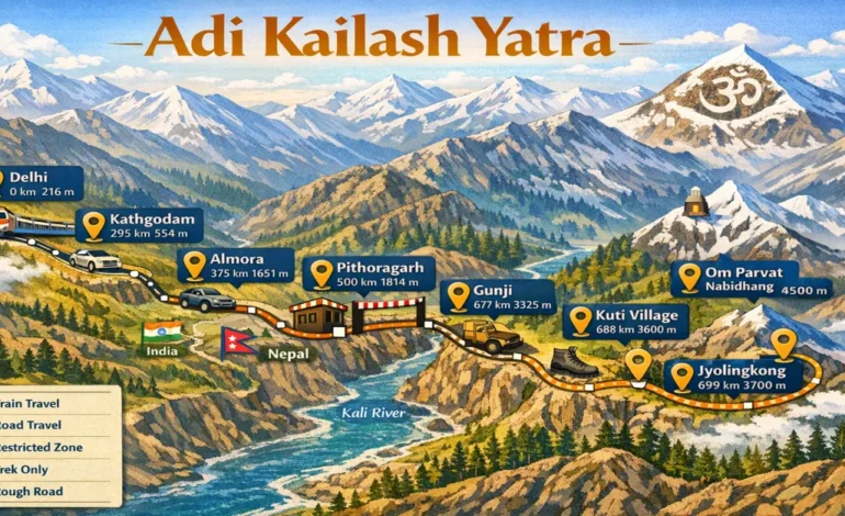
The Adi Kailash trek route map begins from Delhi, passes through Kathgodam, Almora, Pithoragarh, Dharchula, and Gunji before reaching Jyolingkong which is the base of Adi Kailash. A separate day trip from Gunji takes you to the Om Parvat viewpoint at Nabidhang.
Adi Kailash Trek Route Map – Full Distance and Altitude Table
Understanding the distances between each stop on the Adi Kailash trek route map is very important for planning your journey. Here is a complete breakdown of every stop with distance and road condition:
| Stop | Total Distance from Delhi | Altitude | Road Type |
|---|---|---|---|
| Delhi | 0 km | 216 m | Highway |
| Kathgodam | 295 km | 554 m | Highway |
| Almora | 385 km | 1,638 m | Hill Road |
| Pithoragarh | 500 km | 1,814 m | Hill Road |
| Dharchula | 592 km | 915 m | Mountain Road |
| Gunji | 677 km | 3,325 m | Restricted Road |
| Kuti Village | 690 km | 3,600 m | Rough Road |
| Jyolingkong | 699 km | 3,700 m | Trek Only |
| Om Parvat View | 695 km | 4,500 m | Trek Only |
Day by Day Itinerary – Adi Kailash Trek Route Map
Here is a detailed and practical day by day itinerary for the Adi Kailash trek route map that covers the entire journey from Delhi to Adi Kailash and back:
Day 1 – Delhi to Kathgodam (295 km)
The journey begins with an overnight train from Delhi to Kathgodam. This is the most comfortable day of the entire trip and requires no physical effort at all. Take the Ranikhet Express or Kathgodam Express from New Delhi or Anand Vihar Railway Station in the evening. You will arrive at Kathgodam early next morning fresh and ready for the mountains.
| Detail | Info |
|---|---|
| Distance | 295 km |
| Travel Mode | Overnight Train |
| Duration | 6 to 7 hours |
| Trek on This Day | None |
| Difficulty | Very Easy |
| Altitude Change | Delhi 216 m → Kathgodam 554 m |
| Scenery | Plains to Uttarakhand foothills |
| Key Task | Withdraw sufficient cash – last reliable ATM is here |
| Stay | Hotel at Kathgodam – Rs. 500 to Rs. 1,500 |
Day 2 – Kathgodam to Pithoragarh (205 km)
Start driving early from Kathgodam toward Pithoragarh through the beautiful Kumaon hills. The road winds through dense oak and pine forests with stunning views at every turn. Stop at Almora for lunch which is about halfway through the journey. Almora is a charming hill town with great food and lovely views of the Himalayan range. Reach Pithoragarh by afternoon. This town is known as the Little Kashmir of Uttarakhand and it is the last major town on the route with good hospitals, pharmacies, ATMs, and shops.
| Detail | Info |
|---|---|
| Distance | 205 km |
| Travel Mode | Shared Sumo or Private Taxi |
| Duration | 6 to 7 hours |
| Trek on This Day | None |
| Difficulty | Easy |
| Altitude Change | Kathgodam 554 m → Pithoragarh 1,814 m |
| Lunch Stop | Almora – 90 km from Kathgodam |
| Scenery | Kumaon hills, pine forests, Himalayan views |
| Key Task | Buy all medicines, warm clothes, and supplies here |
| Stay | Hotel at Pithoragarh – Rs. 700 to Rs. 2,500 |
Day 3 – Pithoragarh to Dharchula (92 km)
This is a shorter drive compared to the previous day but the road gets narrower and more scenic. The entire route runs alongside the beautiful Kali River which forms the natural border between India and Nepal. You can actually see Nepal from the road at several points. Reach Dharchula by late morning and go directly to the SDM office to collect your Inner Line Permit. This permit is absolutely mandatory for every traveler and without it you will not be allowed to cross beyond Dharchula toward Gunji.
| Detail | Info |
|---|---|
| Distance | 92 km |
| Travel Mode | Shared Sumo or Private Taxi |
| Duration | 3 to 4 hours |
| Trek on This Day | None |
| Difficulty | Easy |
| Altitude Change | Pithoragarh 1,814 m → Dharchula 915 m |
| Scenery | Kali River, Nepal border views, mountain forests |
| Key Task | Collect Inner Line Permit – carry Aadhaar and 4 passport photos |
| Important | Last town with shops and mobile network – stock up on everything |
| Stay | Hotel at Dharchula – Rs. 500 to Rs. 1,500 |
Day 4 – Dharchula to Gunji (85 km)
This is the most adventurous drive on the entire Adi Kailash trek route map. Beyond Dharchula, no private vehicles are allowed. Only government approved vehicles can travel this route. The road is extremely narrow, rocky, and rough in many sections. It climbs steeply from 915 meters at Dharchula all the way up to 3,325 meters at Gunji. The journey passes through remote Himalayan villages, dramatic river gorges, hanging bridges, and stunning waterfalls. The altitude gain on this day is massive so spend the entire afternoon resting at Gunji to allow your body to acclimatize properly.
| Detail | Info |
|---|---|
| Distance | 85 km |
| Travel Mode | Government Approved Vehicle Only |
| Duration | 5 to 6 hours |
| Trek on This Day | None |
| Difficulty | Moderate – rough road, big altitude gain |
| Altitude Change | Dharchula 915 m → Gunji 3,325 m |
| Scenery | River gorges, waterfalls, remote villages, snow peaks |
| Key Task | Rest and acclimatize fully on arrival – do not exert |
| Important | Keep buffer day in schedule – landslides can block road |
| Stay | KMVN Guesthouse Gunji – Rs. 400 to Rs. 1,200 |
Day 5 – Gunji to Om Parvat Viewpoint and Back (36 km round trip)
This is the day that every pilgrim describes as life changing. From Gunji, drive 18 km to Nabidhang where the Om Parvat viewpoint is located. From the viewpoint, the natural snow formation of the sacred “Om” symbol is clearly visible on the face of Om Parvat mountain. The best time to see it is between 8 AM and 10 AM when the sky is clearest. After spending time at the viewpoint for darshan and photography, return to Gunji by afternoon and rest for the big trek day tomorrow.
| Detail | Info |
|---|---|
| Distance | 18 km one way – 36 km round trip |
| Travel Mode | Local 4WD Vehicle to Nabidhang |
| Trek at Viewpoint | 1 to 2 km easy flat walk |
| Duration | 4 to 5 hours total |
| Difficulty | Moderate – altitude of 4,500 m is the challenge |
| Altitude | Gunji 3,325 m → Nabidhang 4,500 m |
| Best Time for Darshan | 8 AM to 10 AM |
| Scenery | Direct view of Om Parvat with Om snow symbol |
| Key Task | Rest entire afternoon – prepare for next day trek |
| Stay | KMVN Guesthouse Gunji |
Day 6 – Gunji to Jyolingkong – Adi Kailash Base (22 km)
This is the most important and emotional day of the entire journey. Start early from Gunji and drive 13 km to Kuti Village. From Kuti Village, the motorable road ends and the trek to Jyolingkong begins. The 9 km trek goes uphill through rocky Himalayan terrain, alpine meadows, and a stunning landscape with glaciers and snow peaks surrounding you on all sides. As you get closer to Jyolingkong, the magnificent Adi Kailash peak comes fully into view and most pilgrims feel overwhelmed with emotion at this sight. At Jyolingkong there is a small temple and the sacred Parvati Tal glacial lake. Spend time in prayer, meditation, and take in the divine atmosphere of this holy place.
| Detail | Info |
|---|---|
| Drive Distance | 13 km – Gunji to Kuti Village |
| Trek Distance | 9 km – Kuti Village to Jyolingkong |
| Total Distance | 22 km |
| Trek Duration | 3 to 4 hours uphill |
| Trek Difficulty | Moderate to Hard – steep rocky uphill at high altitude |
| Altitude Change | Gunji 3,325 m → Jyolingkong 3,700 m |
| Trail Condition | Rocky, narrow, steep in sections |
| Scenery | Glaciers, alpine meadows, Adi Kailash peak, Parvati Tal lake |
| Key Task | Puja at Adi Kailash temple and darshan at Parvati Tal |
| Important | Walk very slowly – altitude makes even flat ground difficult |
| Stay | Basic Camp at Jyolingkong – Rs. 300 to Rs. 800 |
Day 7 – Jyolingkong to Dharchula (Return)
The return journey begins with a 9 km downhill trek from Jyolingkong back to Kuti Village. Downhill is physically easier on the lungs but harder on the knees so walk carefully and use trekking poles. From Kuti Village drive back to Gunji and then continue all the way to Dharchula. The altitude drops rapidly on this day which most travelers find gives them an immediate boost of energy and appetite.
| Detail | Info |
|---|---|
| Trek Distance | 9 km downhill – Jyolingkong to Kuti |
| Trek Duration | 2 to 3 hours downhill |
| Trek Difficulty | Easy to Moderate – downhill, careful on knees |
| Drive Distance | 77 km – Kuti to Dharchula |
| Drive Duration | 4 to 5 hours |
| Total Distance | 86 km including trek |
| Altitude Change | Jyolingkong 3,700 m → Dharchula 915 m |
| Scenery | Same stunning route in reverse |
| Key Task | Descend carefully and steadily |
| Stay | Hotel at Dharchula |
Day 8 – Dharchula to Delhi (Return)
The final day is a long but comfortable journey back to civilization. Drive from Dharchula to Kathgodam covering approximately 387 km through the Kumaon hills. Break the journey with lunch at Almora. Reach Kathgodam by evening and board the overnight train back to Delhi. You will arrive in Delhi the next morning with a heart full of memories and blessings from Adi Kailash.
| Detail | Info |
|---|---|
| Drive Distance | 387 km – Dharchula to Kathgodam |
| Drive Duration | 8 to 9 hours |
| Trek on This Day | None |
| Difficulty | Easy |
| Altitude Change | Dharchula 915 m → Kathgodam 554 m |
| Train | Evening train Kathgodam to Delhi – 6 to 7 hours |
| Key Task | Book return train in advance – fills up fast |
| Stay | Overnight train to Delhi |
Vehicle Guide for Adi Kailash Trek Route
| Stretch | Vehicle | Road Condition |
|---|---|---|
| Delhi to Kathgodam | Train | Excellent Highway |
| Kathgodam to Pithoragarh | Taxi or Sumo | Good Hill Road |
| Pithoragarh to Dharchula | Taxi or Sumo | Moderate Mountain Road |
| Dharchula to Gunji | Govt Vehicle Only | Very Rough Restricted Road |
| Gunji to Kuti | Local 4WD | Extremely Rough |
| Kuti to Jyolingkong | Trek Only | No Road – 9 km Trek |
| Gunji to Om Parvat | Local 4WD | Rough Mountain Road |
Weather and Best Time to Visit
| Month | Temp at Gunji | Condition | Should You Go? |
|---|---|---|---|
| Jan – Mar | -10°C to -2°C | Route Closed | No |
| April | -2°C to 8°C | Unstable | Not Recommended |
| May | 5°C to 15°C | Good | Yes |
| June | 8°C to 18°C | Best Weather | Best Time |
| July | 5°C to 14°C | Heavy Rain | Avoid |
| August | 5°C to 13°C | Dangerous | Avoid |
| September | 4°C to 12°C | Clear and Cool | Very Good |
| October | 0°C to 8°C | Cold but Clear | Good |
| November+ | Below 0°C | Route Closes | No |
Permits Required
| Permit | Where to Get | Documents Needed |
|---|---|---|
| Inner Line Permit | SDM Office Dharchula | Aadhaar Card, 4 Passport Photos |
| Forest Permit | Through Tour Operator | Arranged by Operator |
| Foreign National Permit | District Office Dharchula | Passport and Visa Copy |
Packing List
| Item | Importance |
|---|---|
| Heavy Woolen Jacket and Thermals | Must Have |
| Waterproof Trekking Shoes | Must Have |
| Rain Poncho | Must Have |
| Sleeping Bag -10°C rated | Must Have |
| Trekking Poles | Must Have |
| Sunscreen SPF 50 and Sunglasses | Must Have |
| Headlamp and Power Bank | Must Have |
| First Aid Kit and Medicines | Must Have |
| Water Bottle and Purification Tablets | Must Have |
| Sufficient Cash | Must Have |
| Aadhaar Card and Passport Photos | Must Have |
| Dry Snacks and Energy Bars | Recommended |
Total Budget Table
| Expense | Cost Per Person |
|---|---|
| Delhi to Kathgodam Train | Rs. 300 to Rs. 800 |
| Kathgodam to Dharchula Taxi | Rs. 2,000 to Rs. 4,000 |
| Dharchula to Gunji Govt Vehicle | Rs. 1,500 to Rs. 3,000 |
| Accommodation 8 Days | Rs. 4,000 to Rs. 10,000 |
| Food Entire Trip | Rs. 2,000 to Rs. 4,000 |
| Inner Line Permit | Rs. 200 to Rs. 600 |
| Porter or Guide Optional | Rs. 500 per day |
| Miscellaneous | Rs. 1,000 to Rs. 2,000 |
| Total Budget | Rs. 12,000 to Rs. 25,000 |
Accommodation on the Route
| Location | Options | Cost Per Night |
|---|---|---|
| Kathgodam | Hotels | Rs. 500 to Rs. 1,500 |
| Pithoragarh | Hotels and Guesthouses | Rs. 700 to Rs. 2,500 |
| Dharchula | Hotels | Rs. 500 to Rs. 1,500 |
| Gunji | KMVN Guesthouse | Rs. 400 to Rs. 1,200 |
| Jyolingkong | Basic Camps | Rs. 300 to Rs. 800 |
Altitude Sickness Tips
Gunji sits at 3,325 meters and Jyolingkong at 3,700 meters. Altitude sickness is very common at these heights and every traveler must take it seriously. Walk slowly at all times and never rush even if you feel fine. Drink 3 to 4 liters of water every day. Avoid alcohol completely during the trek. Spend at least one full day at Gunji acclimatizing before going to Jyolingkong. If you experience severe headache, vomiting, or difficulty breathing, descend to a lower altitude immediately without waiting. People with heart conditions or breathing issues must consult a doctor before attempting this yatra.
Nearby Places to Visit
| Place | Distance from Gunji | Highlight |
|---|---|---|
| Om Parvat | 18 km | Natural Om snow symbol |
| Parvati Tal | At Jyolingkong | Sacred glacial lake |
| Kalapani Temple | 60 km from Dharchula | Ancient Kali temple |
| Narayan Ashram | 35 km from Pithoragarh | Beautiful Himalayan ashram |
| Pithoragarh Fort | In Pithoragarh Town | Panoramic mountain views |
Emergency Contact Numbers
| Service | Number |
|---|---|
| Uttarakhand Tourism | 1364 |
| National Emergency | 112 |
| Ambulance | 108 |
Final Thoughts
The Adi Kailash trek route map is not just a travel route — it is a journey of the soul. From the divine sight of Om Parvat’s natural Om symbol to the peaceful Parvati Tal at the foot of Adi Kailash, every single moment of this yatra is deeply moving and unforgettable. Whether you are a devoted pilgrim or a passionate trekker, Adi Kailash will touch your heart in a way that no other destination can.
At DistanceData, Rohan and the team are committed to giving every traveler accurate, helpful, and trustworthy information so that your sacred journey is safe, well planned, and truly memorable. Plan well, walk slowly, respect the mountains, and carry the blessings of Adi Kailash home with you.
All information is researched and verified. Always confirm latest permit and route conditions with local authorities before starting your yatra.