


Uttarkashi and Kedarnath are both sacred towns in the Garhwal Himalayas of Uttarakhand, and many pilgrims doing the Char Dham Yatra pass through both. But despite being in the same mountain region, the road distance between them is longer than most people expect. The Himalayan terrain means you cannot travel in a straight line — you have to descend into river valleys and climb back up, which adds significantly to both distance and travel time.
At DistanceData, managed by Rohan, here is the complete Uttarkashi to Kedarnath distance, route breakdown, travel options, and everything else you need to plan this leg of your yatra.
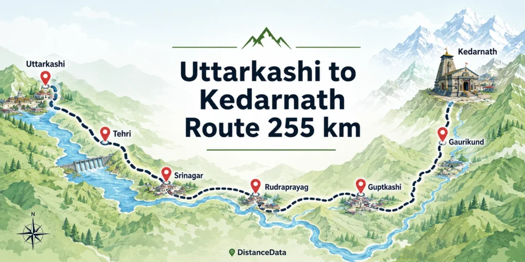
Uttarkashi to Kedarnath Distance
Uttarkashi to Kedarnath distance by road is approximately 227 km and takes around 7 to 10 hours depending on traffic and road conditions. This road distance is up to Gaurikund — the last point where vehicles can go. From Gaurikund, a 16 kilometer trek is mandatory to reach Kedarnath Temple.
The aerial straight line distance between Uttarkashi and Kedarnath is only about 59 km, but the actual road winds through mountain passes, river valleys, and Himalayan towns — making the real distance nearly four times longer.

| Route Segment | Distance |
|---|---|
| Uttarkashi to Tehri | ~80 km |
| Tehri to Srinagar (Uttarakhand) | ~65 km |
| Srinagar to Rudraprayag | ~35 km |
| Rudraprayag to Guptkashi | ~45 km |
| Guptkashi to Sonprayag | ~25 km |
| Sonprayag to Gaurikund | ~5 km |
| Gaurikund to Kedarnath Trek | 16 km |
| Total Road + Trek | ~255 km + 16 km |
Best Route: Uttarkashi to Kedarnath
There are two main routes from Uttarkashi to Kedarnath. The first route goes via Uttarkashi, Srinagar, Rudraprayag, Guptkashi, and Gaurikund to Kedarnath, covering approximately 285 kilometers.
The second and more commonly used route is:
Uttarkashi → Dharasu → Chinyalisaur → Tehri → Srinagar → Rudraprayag → Guptkashi → Sonprayag → Gaurikund → Kedarnath
This route covers approximately 300 km and takes around 12 hours including stops. The road passes through Tehri — where you cross the massive Tehri Dam reservoir — and then drops into the Alaknanda valley at Srinagar before turning south toward Rudraprayag and the Mandakini valley that leads to Kedarnath.
After Rudraprayag, the terrain gets steeper and roads narrower. This stretch requires careful driving, especially during and after monsoon season when landslides are common.
Travel Options: Uttarkashi to Kedarnath
There are different- different Travel Option is there
By Road (Cab or Self Drive)
Road is the only practical way to travel between Uttarkashi and Kedarnath since neither city has a railway station or airport. Uttarkashi to Kedarnath taxi fare is approximately ₹2,497 for a sedan and approximately ₹3,405 for an SUV. Uttarkashi to Kedarnath Innova fare is approximately ₹4,405.
Most pilgrims doing the Char Dham Yatra already have a cab booked for the entire circuit. If you are traveling independently, shared jeeps from Uttarkashi toward Rishikesh or Haridwar and then onward to Gaurikund are the budget option.
By Helicopter (Final Leg)
Helicopter services are available from Phata to Kedarnath. The distance between Uttarkashi and Phata is approximately 250 kilometers. The helicopter ride from Phata to Kedarnath takes approximately 10 to 15 minutes and is subject to weather conditions and availability.
If you want to skip the 16 km trek, reach Phata or Guptkashi by road and take the helicopter from there. Book helicopter tickets well in advance through the official Uttarakhand government portal.
By Train or Flight
There are no direct train services available from Uttarkashi to Kedarnath. Uttarkashi does not have a railway station and the nearest railway station to Kedarnath is Rishikesh or Haridwar, approximately 235 kilometers from Uttarkashi. There are no direct flights available from Uttarkashi to Kedarnath as neither destination has an airport. The nearest airport to Kedarnath is Jolly Grant Airport in Dehradun, approximately 239 kilometers from Uttarkashi.
Travel Options at a Glance
| Mode | Distance | Travel Time | Cost (Approx) | Best For |
|---|---|---|---|---|
| Self Drive / Cab | ~255 km | 8–10 hrs | ₹2,500–₹4,500 | Families, groups |
| Shared Jeep | ~255 km | 10–12 hrs | ₹500–₹1,000 | Budget travelers |
| Helicopter (last leg) | 16 km aerial | 10–15 mins | ₹3,000–₹5,000 | Elderly, fitness issues |
Uttarkashi: An Important Stop on Char Dham Yatra
Most pilgrims traveling from Uttarkashi to Kedarnath are doing the full Char Dham Yatra. Uttarkashi is the base town for Gangotri Dham, one of the four Char Dhams. After completing Gangotri darshan, pilgrims proceed toward Kedarnath as the next Dham.
Uttarkashi means Kashi of the North and is a holy town situated on the banks of river Bhagirathi at an altitude of 1,352 meters. It is home to a number of ashrams and temples including the Kashi Vishwanath Temple at its center.
Uttarkashi is also home to the famous Nehru Institute of Mountaineering, making it a significant town for both pilgrims and trekkers. The town has good hotels, restaurants, ATMs, and fuel stations — all essential before heading into the more remote mountain terrain toward Kedarnath.
Char Dham Distances from Uttarkashi
Since most travelers going from Uttarkashi to Kedarnath are on a Char Dham circuit, here is the complete distance reference from Uttarkashi to all four Dhams.
| Char Dham | Distance from Uttarkashi | Travel Time |
|---|---|---|
| Gangotri | ~100 km | 3–4 hrs |
| Yamunotri | ~126 km | 5–6 hrs |
| Kedarnath | ~255–300 km | 10–12 hrs |
| Badrinath | ~323 km | 12 hrs |
Gangotri is the closest and most commonly visited from Uttarkashi. After Gangotri darshan, the standard Char Dham route continues toward Kedarnath via Tehri and Rudraprayag.
Recommended Itinerary: Uttarkashi to Kedarnath
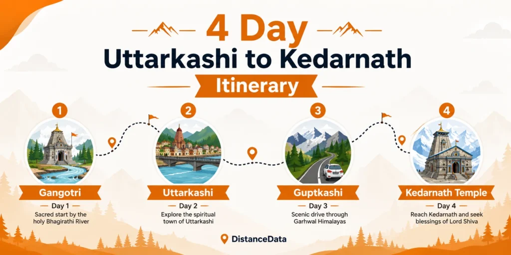
| Day | Plan |
|---|---|
| Day 1 | Gangotri darshan, return to Uttarkashi, overnight stay |
| Day 2 | Depart Uttarkashi early morning, drive to Guptkashi via Tehri and Rudraprayag |
| Day 3 | Guptkashi to Gaurikund, begin trek early, reach Kedarnath, darshan, overnight |
| Day 4 | Morning darshan at Kedarnath, trek back to Gaurikund, drive return |
Starting the drive from Uttarkashi early — by 5 or 6 AM — is important. The road to Gaurikund is long and mountain driving after dark is best avoided.
Key Stops Between Uttarkashi and Kedarnath
The route from Uttarkashi to Kedarnath passes through several significant towns worth knowing about.
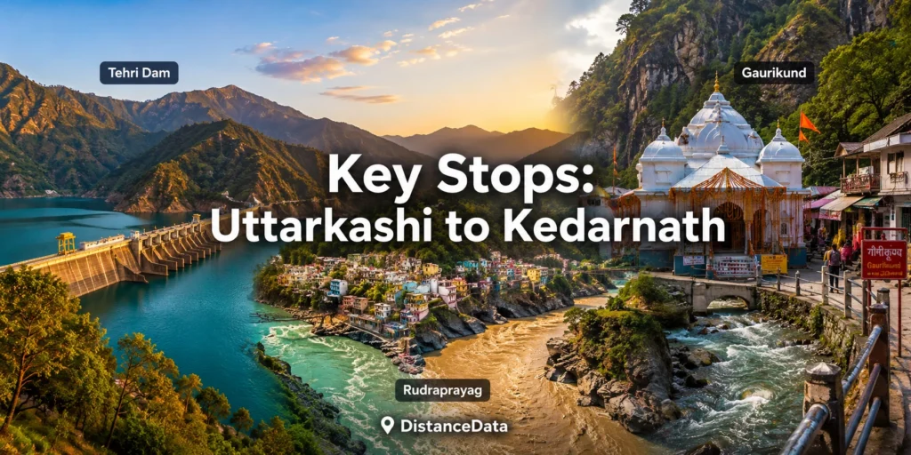
| Stop | Distance from Uttarkashi | What to Know |
|---|---|---|
| Tehri | ~80 km | Tehri Dam and reservoir, fuel stop |
| Srinagar (Uttarakhand) | ~145 km | Largest town on route, good hotels |
| Rudraprayag | ~180 km | Alaknanda-Mandakini confluence |
| Guptkashi | ~225 km | Vishwanath Temple, last major town |
| Sonprayag | ~248 km | Registration check post for Kedarnath |
| Gaurikund | ~253 km | Last motorable point, trek starts here |
Best Time to Travel
Kedarnath Temple opens in late April or early May and closes in October or November. The travel window from Uttarkashi aligns with the same Char Dham season.
| Season | Months | Conditions |
|---|---|---|
| Opening | Late April – May | Temple opens, book everything in advance |
| Peak | May – June | Maximum pilgrims, roads crowded |
| Post Monsoon | September – October | Best weather, clear views, moderate crowds |
| Closing | October – November | Temple closes, snowfall begins |
September and early October is the best window for this journey. The roads are clear after monsoon, weather is comfortable, and the Himalayan scenery on the Tehri to Rudraprayag stretch is absolutely stunning in autumn.
Practical Tips
Uttarkashi has the last reliable ATMs before Kedarnath — withdraw enough cash here. Fuel up in Uttarkashi or Srinagar before heading deeper into the mountains. Carry warm clothes even in May and June as Kedarnath temperatures drop sharply at night.
Online Char Dham Yatra registration is mandatory — complete this before leaving Uttarkashi. Keep your Aadhaar card accessible as there are multiple checkpoints on the route. If you are combining Gangotri and Kedarnath in one trip, plan at least 4 days to do both comfortably without rushing.